
Alberto Puente-Rolon (Universidad Interamericana de Puerto Rico, Recinto de Arecibo) and I were incredibly fortunate to spend a week on the Cay Sal Bank, Bahamas. Cay Sal is a partially emergent island bank situated about 100 km south of Islamorada in the Florida Keys and about 50 km north of the Cuban Bank in the vicinity of Sagua la Grande. Politically part of the Commonwealth of the Bahamas, the bank is separated from the Great Bahama Bank by the 47 km-wide Santarem Channel, and is about 175 km west of the southern tip of Andros Island. Cay Sal Bank is a shallow carbonate platform with dozens of small emergent islands around the edges of the roughly triangular-shaped bank.

Anolis sagrei, Cay Sal Island. Photo by Alberto Puente-Rolon.
A note before we launch into the narrative of our trip. The Cay Sal Bank is an area known for a significant amount of illegal activity. This largely involves illegal fishing fleets and human trafficking. While a typical visitor to the area would not likely be in great danger from these activities, there is always the possibility that you might run into the wrong people at the wrong time. Illegal fishing vessels have been known to harass, intimidate, and attempt to board cruising vessels on Cay Sal, while happening upon a human or drug trafficking exchange could be extremely dangerous. We saw evidence of all of these activities during our cruise, and mention some specifics in the narrative below. In addition, the Cay Sal Bank is remote. There are occasional Coast Guard planes in the area, but keep in mind that there might not be many vessels able to monitor emergency radio channels (channel 16) or respond quickly to an emergency. We cruised to the region with a highly experienced crew and a very well maintained and outfitted vessel, and we recommend anyone else planning to visit do the same, as well as consider taking all available safety precautions. I am happy to discuss my experiences in detail with researchers interested in visiting the area.

Anolis fairchildi, Cay Sal Island. Photo by RGR.
We arrived on the bank at dawn after an overnight cruise from Bimini, where we had cleared Bahamas customs and immigration. Our first stop was Dog Rocks, where we were able to disembark and swim ashore for a short walkabout on the largest of the small rocks jutting out of the ocean. The Dog Rocks mark the eastern edge of the Cay Sal Bank, and as far as we were aware there were no herpetofaunal records from these islands. Most are rocky and jagged, likely washed over during hurricanes and largely devoid of vegetation. Great Dog Rock is quite small, with a patchy covering of ground vegetation. There is a single large, pyramid shaped stand of Cocoloba uvifera near the center of the island-

Cocoloba uvifera stand on Dog Rocks. Photo by Alberto Puente-Rolon.
approximately 5 meters high and 10 meters wide. Quite a few Sooty Terns (Onychoprion fuscatus) and Brown Noddies (Anous stolidus) nest here. Even in this very isolated and largely barren stretch of rocks, we managed to locate Anolis sagrei. The large males and robust females were mostly occupying the Cocoloba stand, though we did find juveniles, young males, and females on the ground near the scrub vegetation. We even located a juvenile underneath a discarded conch (Strombus gigas) shell. We spent about two hours here, plenty of time to survey the entire island. We did not find evidence of any other terrestrial reptiles, and it is quite remarkable that even A. sagrei could persist there.

Departure from Cay Sal Island. Photo by RGR.
Our next stop was at the Damas Cays, a small group of narrow, high-walled islets jutting out along the spine of the eastern Cay Sal Bank. Like Dog Rocks, we are unaware of any herpetofaunal records from Damas, and for good reason. We took a rigid inflatable boat out for a brief survey of the largest of the Damas Cays. There are no easy landing spots on the island, so landing would require a swim. There was very little vegetation, we spotted a single small shrub and some very sparse groundcover. As we approached the island to land, we lost power on our outboard engine and were losing daylight, so we opted to repair the engine and not to clamber ashore.

Cay Sal Island. Photo by RGR.
We then cruised across the bank to the southwestern edge, about 80 km from Cuba. This is where the largest island in the Cay Sal group is located, the eponymous Cay Sal Island. This island is about 1.7 km long and 1 km wide. There is a large salina in the center, with an exit to the sea on the south side. Cay Sal previously housed a Bahamas immigration station, though the island is now a major camping ground for illegal fishing boats (poachers). We saw ample signs of human disturbance- large trash accumulations, bottles, shotgun shell casings, and so on. We heard a number of boat engines in the salina- a large diesel engine and several outboards roared to life as the fishermen left the interior lagoon as the sun came up, probably to go fishing for the day.

Dr. Puente-Rolon surveys Cay Sal Island, with the central lagoon in the background. Photo by RGR.
There were lots of footprints around the beaches and in the interior. We kept to the edges of the forest to try to minimize any encounters with others.
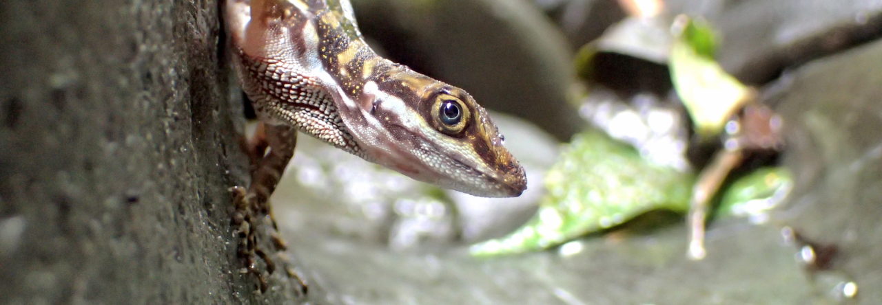
Despite the obvious human disturbance, Cay Sal is a beautiful island. It is heavily vegetated with silver palms, mangroves, grasses, shrubs, and some coconut palms. The soil is sandy, with very few rocks, and a 10 m high sand ridge runs northwest to southeast and is covered with patches of silver palms. All of this lush vegetation provides ample habitat for Anolis sagrei and Anolis fairchildi, which we found in great abundance. We landed on the island at dawn, and the green anoles were the first to stir from the fronds of silver palms backing against the dense black (Avicennia germinans) and white (Laguncularia racemosa) mangrove stands.

Casuarina stand on Elbow Cay, with Brown Noddies in the foreground. Photo by RGR.
The male A. fairchildi are impressively large- about 75mm SVL. They are also quite strong- they exert a surprisingly strong grip on palm fronds! Their dewlaps are relatively narrow, with a pinkish hue and white scales interspersed. As the morning went from warm to baking in the August sun, the green anoles moved up into the tops of the palms, and the brown anoles came out in huge numbers. Alberto kneeled beneath a stand of coconut palms and shuffled the fallen fronds. The brown anoles materialized from all directions, jumping to the ground to grab ants that were now scurrying about. We also saw abundant sea turtle tracks and nesting activity on the beaches, though at least one nest that appeared to have been dug up by a person.
After Cay Sal, we cruised to the northwestern edge of the bank, disembarking at Elbow Cay just after dawn. Elbow Cay is a fairly elevated island with the ruins of a 19th century lighthouse and associated outbuildings. The island is very rocky and is covered with low scrubby vegetation, save for a small Casuarina stand near the peak of the island.

Tropidophis curtus from Elbow Cay. Photo by Alberto Puente-Rolon.
We found a very low abundance (fewer than 25 individuals) of A. sagrei– mostly near the Casuarina stand. There are also records of Anolis fairchildi and Tropidophis curtus from Elbow Cay- and we were fortunate enough to find a single individual trope climbing from beneath a rock into a small Sea Lavender (Tournefortia gnaphalodes) shrub. We do not think that A. fairchildi actually occurs here, as there appears to be insufficient vegetation and we saw no individuals during our survey.
Our next stop was an afternoon survey of Doubleheaded Shot Cay, which is a few km east of Elbow Cay and is a component of the necklace of narrow islands forming the northern border of the Cay Sal Bank. This island is long and narrow, with significantly more vegetation than other islands on the northern end of the bank.

Anolis fairchildi front toepads. Photo by RGR.
Parts of the island are quite lush with low vegetation thick enough that it is difficult to penetrate. Some larger mangroves are also present. A single herpetofaunal record exists (to our knowledge) for this island- Tropidophis curtus. We did not find any tropes; nevertheless, we found a generally low abundance of Anolis sagrei, and did not observe any other species of reptiles.
Our final stop was an afternoon survey of two of the Elephant Rocks, east of Elbow Cay. These are relatively tall and very narrow islands which provide habitat for large densities of Brown Boobies (Sula leucogaster), Sooty Terns, and Brown Noddies. Vegetation is scant and what shrubs do exist are very low to the ground. The terrain is steep and requires scrambling up and down steep and jagged cliffs.

Elephant Rocks, looking east. Photo by RGR.
No herpetofaunal records exist for these islands as far as we are aware, an unsurprising situation given the apparent lack of suitable habitat. However, happily, we discovered Anolis sagrei on these cays, though in low abundance. All the individuals we saw were using rocks and small caves as cover and refuge, and were very skittish when approached. This apparently saxicolous population of A. sagrei would be interesting to follow up on, particularly given our (collective) thoughts about how habitat influences evolutionary trajectories of anoles.
The only other islands with significant vegetation that we were unable to visit are the Anguilla Cays. This group marks the southeastern edge of the bank, and like all islands on the bank (except for Cay Sal) are long and narrow. Records from Anguilla include Anolis sagrei and a recently discovered Cubophis cantheridgus (Krysko et al. 2015).
Herpetofaunal records are from:
Buckner, S.D., R. Franz, and R.G. Reynolds. 2012. Bahama Islands and Turks & Caicos Islands. In: R. Powell and R.W. Henderson (Eds.). Island Lists of West Indian Amphibians and Reptiles. Bulletin of the Florida Museum of Natural History 51: 85-166.
Available at: http://www.rgrahamreynolds.info/wp-content/uploads/2012/09/BFMNH_2012.pdf
Other References:
Krysko, K.L., D.W. Steadman, L.P. Nuñez, and D.S. Lee. 2015. Molecular analyses of Caribbean dipsadid (Xenodontinae: Alsophiini) snakes, including identification of the first record from the Cay Sal Bank, The Bahamas. Zootaxa. 4028:441–450.
Mackin, W. 2012. The Seabirds of the Cay Sal Bank, a wild and unconquered atoll in the Bahamas. Caribbean Birds blog post. Available at: http://www.birdscaribbean.org/2016/01/the-seabirds-of-the-cay-sal-bank-a-wild-and-unconquered-atoll-in-the-bahamas/

- The Alluring Anoles of Alto Velo - July 19, 2025
- A Victorian Mystery – the Lizard Dewlap - October 10, 2020
- Undergraduates among the Anoles: Anolis scriptus in the Turks & Caicos - July 14, 2020
James Stroud
Wonderful report! Thanks for posting.
Any more pictures of A. fairchildi? For such an obscure member of the carolinensis clade, those deserve a post on their own!
Professor Lee B. Kass
I found it interesting that you showed an image of Coccoloba uvifera on Cay Sal. In January 1976 Gillis reported a list of plants that should have been there but were not-C uvifera and Australian Pine is on his list of many (Gillis 1976, Bahamas Naturalist, Vol. 2, no. 1, p. 36-41)). He found only a few Rnizophora mangle in a lagoon. Thanks for your post-Professor L.B. Kass, Cornell University